Arizona County Map : Arizona is a state in the southwestern part of the United States. Arizona has a rich history and culture. The state was originally occupied by Native American tribes such as the Navajo, Hopi, and Apache.
Related Post –
- Kentucky County Map
- North Carolina County Map
- Tennessee County Map
- Illinois County Map
- Pennsylvania County Map
Arizona County Map [AZ County Map]
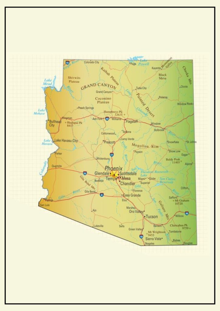
Arizona has a strong Native American heritage. There are 22 federally recognized tribes within the state, and Native Americans constitute approximately 5% of the population. Arizona is also well known for attracting retirees and snowbirds. Arizona is split into 15 counties, each of which has its own distinct personality and attractions.
- Apache County
- Cochise County
- Coconino County
- Gila County
- Graham County
- Greenlee County
- La Paz County
- Maricopa County
- Mohave County
- Navajo County
- Pima County
- Pinal County
- Santa Cruz County
- Yavapai County
- Yavapai County

Arizona’s map of counties is a reflection of the diversity of the state and its numerous strengths. The cities and counties of Arizona combine to form a prosperous and thriving state.
Arizona Map with County and Cities

Arizona is a southwestern state in the United States, characterized by diverse landscapes such as deserts, mountains, and forests. It is also where the Grand Canyon, one of the Seven Natural Wonders of the World, is located.
Here are a few examples of the ways that Arizona’s cities and counties collaborate:
- The city of Phoenix has within it the Phoenix Sky Harbor International Airport, a major transportation hub for the entire state.
- City of Tucson hosts the University of Arizona, which is a top-ranked research university.
- Flagstaff city houses the Lowell Observatory, one of the world’s most renowned astronomical observatories.
- The Marine Corps Air Station Yuma, one of the principal training bases for the United States Marine Corps, is located in this city of Yuma.
Cochise County Map Arizona [Arizona County Map]

It is bordered by Mexico to the east and south, and by the counties of Graham to the north, Pima to the west, and Greenlee to the northeast. Cochise County is the sixth largest county in Arizona by land area, covering a total of 6,219 square miles.
The Cochise County map is an indication of the county’s varied landscapes and attractions. This Arizona County Map indicates the county’s principal cities and towns, and its highways, rivers, and mountains. The Arizona County Map also indicates the county’s national parks and monuments.
Some of the things Cochise County is famous for are:
- Tombstone Courthouse State Historic Park: This park maintains the courthouse where the Earp brothers and Doc Holliday confronted the Clanton gang in the Gunfight at the O.K. Corral.
- Chiricahua National Monument: This park features a range of unusual geological formations, such as hoodoos, spires, and balanced rocks.
- Fort Huachuca: This active military installation is the home of the United States Army Intelligence Center and Fort Huachuca.
- Sierra Vista: This city is the site of Cochise College and the Arizona State Prison Complex – Douglas.
Cochise County is a lovely and diverse county with something to suit everyone.
Mohave County AZ Map
The north -western end of Arizona is an area of Mohve County, dramatic contradictions and natural splendor. On a map of Mohve County, the Mojave will discover a diverse landscape from the rigid desert landscape of the Mojave desert for breathtaking views of a colloidal plateau. County is placed with several cities and towns, such as Kingman’s busy cities, tourist cities of Havasu city with its famous London Bridge and the historic mining city of Bullhead City on the Colorado River.
Inter -State 40 and U.S. Route 93 -like highway run through county, which provides important transport routes. The Grand Canian West, Havasu National Wildlife Refuge, and Sightsee Lake Mead may be located on the map, showing the external entertainment opportunities of the county. With a land mass of over 13,000 square miles and a population of about 200,000 inhabitants, the map of Mohve County is the key to both the life of his city and the land of its vast range, which offers the rich and diverse nature of this Arizona outpost.