Florida is famous for its warm climate, lovely beaches, and numerous tourist spots. The state also boasts a range of natural attractions such as the Everglades, the Florida Keys, and the Dry Tortugas.
Related Post –
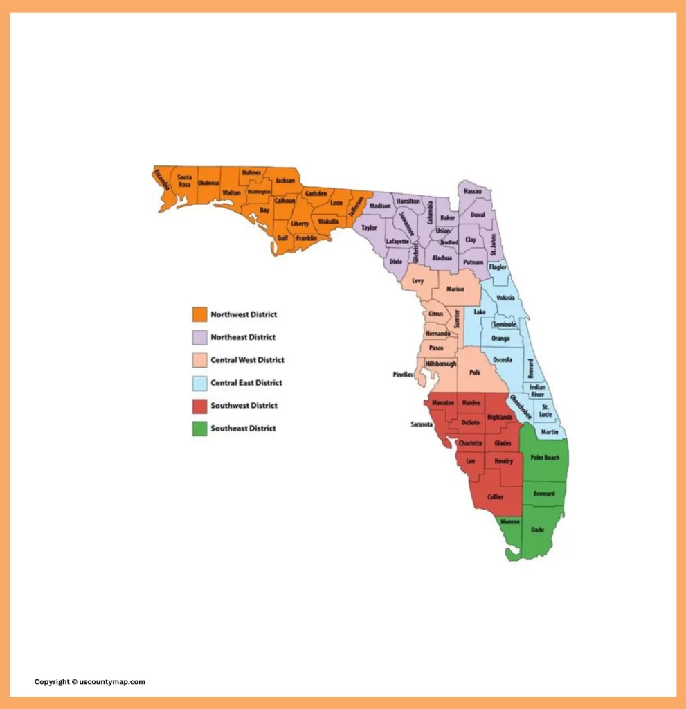
Florida County Map
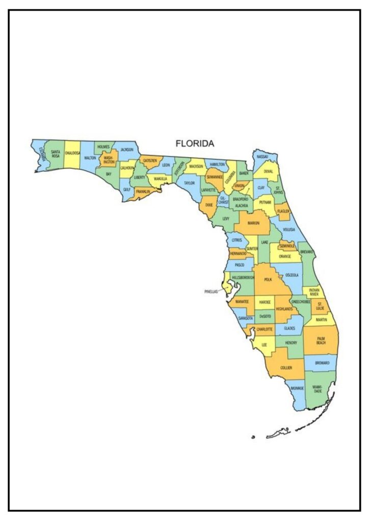
Florida, popularly known as the “Sunshine State,” has a diverse patchwork of 67 counties that help to shape the state’s character and identity. These counties are a rich mosaic that illustrate Florida’s geographical, cultural, and historical diversity.
One of the most striking characteristics of Florida’s county map is its orientation to the coast. Florida is bordered by water on nearly all sides, with the Atlantic Ocean to the east and the Gulf of Mexico to the west.
Conversely, northern counties of the state, such as Leon and Alachua, are more temperate in climate and are famous for their natural beauty and lively college towns. The central area, with counties such as Orange and Hillsborough, boasts the thriving metropolis of Orlando and Tampa, respectively, and is a center for entertainment, business, and culture.
Florida’s county map also bears witness to its cultural diversity. South Florida, with its predominantly Cuban and Hispanic flavor, stands in contrast to the more conventionally Southern and rural nature of North Florida. The state’s Native American past is visible in such countries as Seminole, while others, such as Sarasota and Collier, have a cosmopolitan feel to them, luring retirees and tourists alike.
Historically, the counties of Florida have been critical in defining its past. St. Augustine, located in St. Johns County, is the oldest city in the country, dating to 1565. The Everglades, stretching across multiple counties, is a UNESCO World Heritage site and represents the state’s dedication to the protection of the environment.
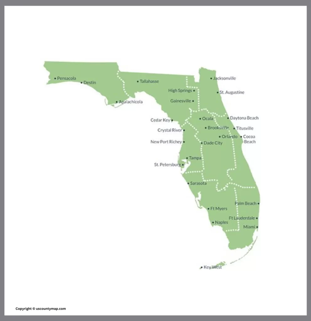
Map of Florida Counties and Cities
Florida’s county and city map is an intriguing study of the state’s rich complexity. It is a guide both for natives and for tourists alike, a window into the varied geography and culture that make the Sunshine State such a unique and dynamic place
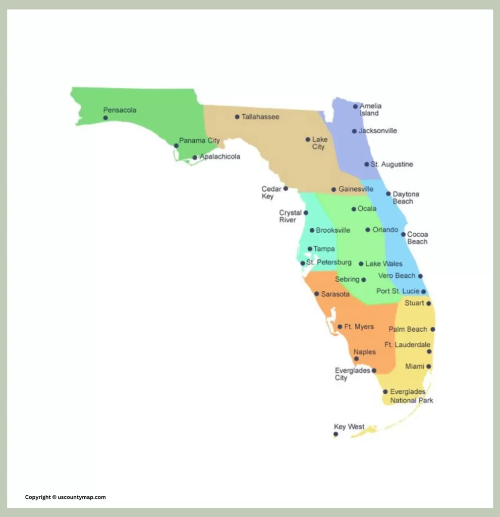
Florida county and city map is an important resource for learning about the geography and population of the state. It can be utilized to locate places, including cities, towns, and villages. It can also be utilized to learn about the various parts of Florida, including the Panhandle, the Gulf Coast, and the Florida Keys.
These are some of Florida’s most populous cities:
- Miami
- Orlando
- Tampa
- Jacksonville
- Fort Lauderdale
- St. Petersburg
- Miami Gardens
- Hialeah
- Port St. Lucie
- Cape Coral
- Orlando metropolitan area
The cities have numerous businesses, sites, and institutions of culture. They are also key transportation hubs, with seaports, airports, and highways linking them to the remainder of the state and the globe.
Map of FL Counties [Florida County Map]
Florida counties map is a useful tool for anyone who would like to learn more about the state. It can be applied to research, planning, and daily navigation.
Some of the interesting facts regarding the Florida counties map include:
- The counties have been named after a range of things such as people, places, and geographical features.
- The counties are separated into various regions, each of which has its own character.
- The counties contain a range of different cultures and communities.
- The counties change on a regular basis, with new towns and cities being built and the population increasing.
The Florida counties map is an ever-changing document that shows the evolving nature of the state. It is an excellent source of information for anyone interested in knowing more about Florida’s history, current affairs, and future.
State of FL Map with Counties [Florida County Map ]

The state of Florida is surrounded by the Gulf of Mexico to the west and south, the Atlantic Ocean to the east, and Alabama and Georgia to the north. Florida is the 22nd largest state in the United States by land area and the 2nd most populous state with a population of over 21 million people. It is made up of 67 counties. The counties are further divided into cities, towns, and villages.
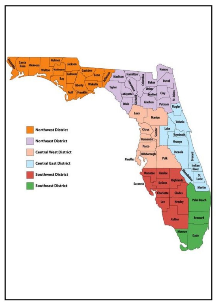
The Florida county map indicates that the state is comprised of four large regions: the Panhandle, the Gulf Coast, the Central Florida area, and the Northeast Florida area.

Some of the most populated counties in Florida include:
- Miami-Dade County (population: 2,701,767)
- Broward County (population: 1,975,140)
- Pinellas County (population: 984,374)
- Orange County (population: 1,589,236)
- Hillsborough County (population: 1,451,377)
- Duval County (population: 988,372)
- Lee County (population: 786,623)
- Palm Beach County (population: 699,749)
- Pasco County (population: 819,500)
- Collier County (population: 723,017)
These counties have some of the biggest cities in Florida, including Miami, Fort Lauderdale, Orlando, and Tampa. They also have some of the tourist attractions in Florida, including the Miami Beach and Fort Lauderdale beaches, the Orlando theme parks, and the Florida Keys’ natural beauty.
Washington County Florida Map
Washington County is a county in the Panhandle of Florida, in the northwest section of the state. It’s rural, picturesque, and historic. Here’s a description of what you might see on a map of Washington County, Florida:
- Cities and Towns: The map would indicate the cities, towns, and unincorporated communities in Washington County. This would include the county seat, Chipley, and other populated places like Vernon, Wausau, and Ebro.
- Roads and Highways: The major highways, roads, and smaller roads that link the different communities in the county would be illustrated. These include U.S. Route 90, State Road 77, and other local roads.
- Natural Landmarks: The map can emphasize natural landmarks like rivers, creeks, lakes, and forests. Washington County has natural places such as Falling Waters State Park, which contains Florida’s highest waterfall.
- Boundaries: The map would also illustrate the boundaries of Washington County, indicating its borders with other counties like Holmes County to the north, Jackson County to the east, Bay County to the south, and Walton County to the west.
- Facilities and Points of Interest: Significant facilities and points of interest would be labeled on the map. This encompasses schools, government buildings, parks, recreational facilities, and landmarks. For instance, the Washington County Courthouse, schools, and recreational facilities such as the Hard Labor Creek Off-Road Park.
- Population and Area: The map can also have population data like numbers of people and land area measures for Washington County. At the time of my update in 2022, the population of Washington County stood at about 25,000 individuals and occupied approximately 583 square miles.
In general, Washington County, Florida, Map is an effective tool for local people, tourists and companies, which provides geographical details and facilitates navigation around the county.