Ohio County Map – Ohio is a state in the Midwestern United States. Ohio is a culturally and historically rich state with a diverse landscape and a unique blend of urban and rural lifestyles. It is a fascinating state to reside in or to visit.
Ohio County Map
County Map of Ohio
Ohio, a state at the center of the American heartland, is a rich tapestry of diversity, heritage, and regional identity. Its county map, which comprises 88 separate counties, expresses the state’s rich history, economic diversity, and geographical differences. Each county has a different story to tell, making Ohio a microcosm of the United States.
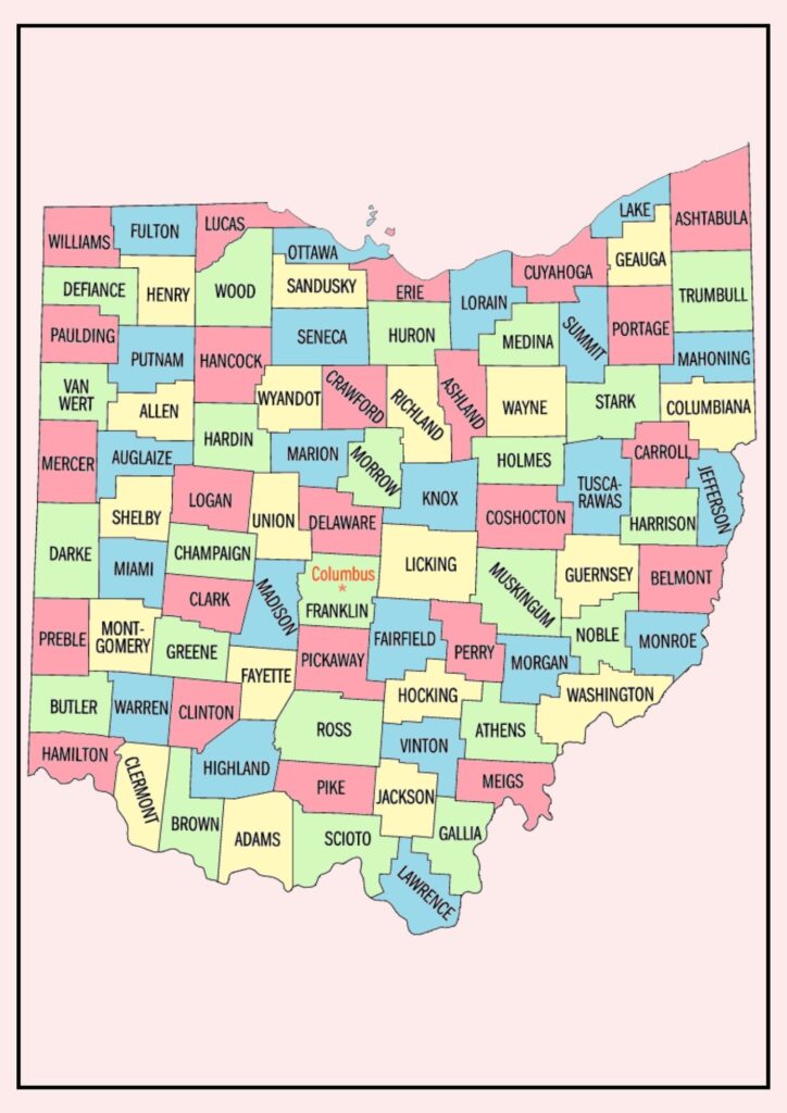
The Ohio County Map possesses a long and multifaceted past. The original counties were formed in 1799, immediately after Ohio entered the Union as a state. The counties changed in number, with new ones being formed and others merged over time. There are 88 counties now as of 1808.
Here are some further facts about Ohio’s county map:
- The county seats of Ohio are the administrative centers of the county. The largest county seat is Columbus, the capital of Ohio.
- The Ohio counties are subdivided into townships, which are local government units smaller than the county. Townships provide a range of services, including road maintenance and trash collection.
- The Ohio counties are also subdivided into school districts, which provide public education.
- The Ohio county map is not static. Counties may be combined or split, and county boundaries also shift.
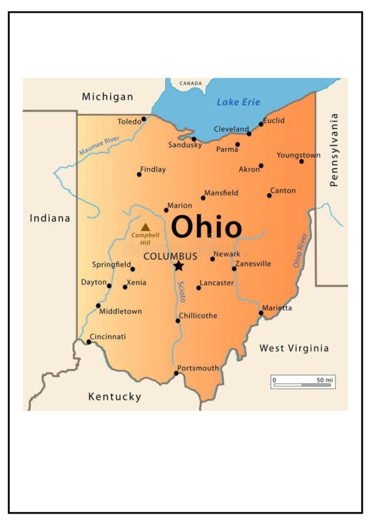
Map of Ohio Counties and Cities
Ohio County Map and cities is a useful resource to understand the geography and demographics of the state.
The counties in Ohio differ in terms of size and shape. Ashtabula County is the largest county in Ohio with a total area of 1,026 square miles. Vinton County is the smallest county with a total area of 226 square miles. The population of the counties of Ohio also differs significantly. The densest county is Cuyahoga County with a population of more than 1.3 million people. The least densely populated county is Vinton County with a population of less than 13,000 people.
Following are some of the most populated cities in Ohio, along with their county and population:
- Columbus (Franklin County): 905,748
- Cleveland (Cuyahoga County): 385,525
- Cincinnati (Hamilton County): 296,943
- Toledo (Lucas County): 287,203
- Akron (Summit County): 202,533
- Dayton (Montgomery County): 140,640
- Parma (Cuyahoga County): 87,838
- Youngstown (Mahoning County): 68,080
- Canton (Stark County): 73,364
- Lorain (Lorain County): 68,358
The Ohio county map and cities is a useful tool for anyone who resides in, visits, or conducts business in Ohio. It is an informative tool for learning about the state and its citizens.
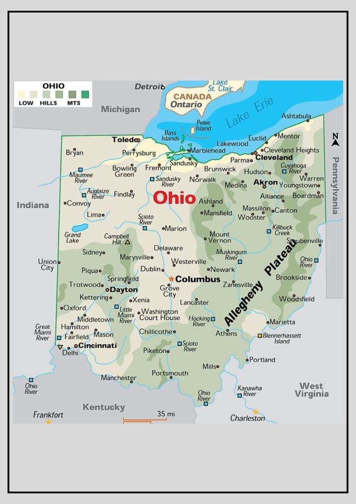
Ohio State Map of Counties [Ohio County Map]
Native American groups, such as the Shawnee, the Wyandot, and the Miami originally populated the state. The first European colonists arrived in the 17th century, and the state joined the Union in 1803.
The Ohio state provided a significant number of troops and supplies to the Union forces, and there were a number of important battles in Ohio, including the Battle of Gettysburg.
Following the Civil War, Ohio transformed into a leading industrial powerhouse. The state hosted numerous steel mills, auto factories, and other manufacturing plants. Ohio also emerged as a leading agricultural state, cultivating corn, soybeans, and wheat.
Today, Ohio is a leading business, education, and healthcare center. The state boasts a number of Fortune 500 companies, including Procter & Gamble, Marathon Petroleum, and American Electric Power. Ohio also has a number of universities, including Ohio State University, the University of Cincinnati, and Miami University.
Ohio possesses a solid economy, a diverse population base, and a rich history. If you are searching for a place to call home, Ohio is an ideal choice.